Turtlegrass is situated in Calabash Bight, Roatán, Bay Islands, Honduras, C.A. We currently have over 400 feet of commercial grade docks, with a combination of side or stern mooring. The slips will accommodate boats of up to 60 ft length and 9 ft draft. Calabash Bight is one of the best hurricane holes outside of the Rio Dulce and is also outside the "hurricane box" so vessel insurance is allowable through most insurers. Unlike the Rio, you can fly down, board, sail to Port Royal and watch the sun set on the edge of a coral reef in the same day.
Rates
Dockage:
Services:
- Monthly rate is $5 per foot, per month for 1-2 months terms. $4 per for foot for 3 or more months. $3 foot for storage only.
- For extended stays, dinghy and outboard storage is available if needed
- 100v 30 amp power additional @ $.50 per KWH (metered)
Services:
- At Turtle Grass Marina, included in the long term moorage fee we open all boats twice a week, weather permitting to keep the interior from building up heat and humidity and also check regularly for leaks and we check batteries at least once a week. For an additional fee we will wash the outside and clean inside as desired.
- Reverse Osmosis water fill ups: $1.5 per 5 gallon container (Potable Water)
- Laundry services available
- Nightly customers receive free WiFi during stay
- Trash disposal
- Arrangements can be made for haulouts with a local yard
- 24 hour on site management and security
- Loyalty incentive programs; The more times you visit the cheaper the rate. Refer a friend and receive 40% off your next months rate.
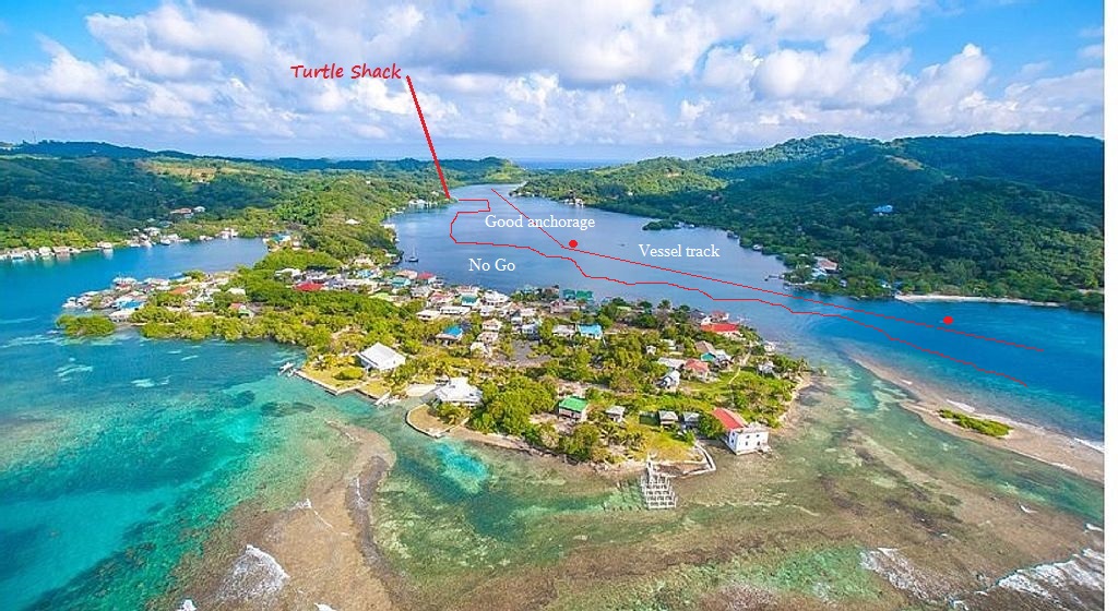
Entry to Calabash
For those cruising the NW Caribbean who find themselves in Roatán, Calabash Bight is a quiet place to anchor and rest. It also happens to be the best hurricane hole on the island! Here's some guidance on navigating the entrance to Calabash Bight::
16 23.430 N 86 20.066 W Approach Outside (initial)
16 23.521 N 86 20.131 W Approx Red entry marker
Lay a course of 320 Deg. Magnetic and you will spot the next marker (Red) and stay in good water on this course.
16 23.743 N 86 20.295 W Next to red inner marker turn toward the back of the bight. (this marks a cut about 60 foot wide channel 10 to 12 feet deep)
16 23.893 N 86 20.374 W One of the anchorage spots. Once inside you can anchor in several locations up and down the bight by eyeball navigation as water is clear enough to see bottom in shoal areas.
Turtlegrass: 16.24.02 N 86.20.22 W Look for the point on the West side that is half way up in the bight.